Fichier:Anguilla map.svg

Taille de cet aperçu PNG pour ce fichier SVG : 800 × 381 pixels. Eutes résolucions : 320 × 152 pixels | 640 × 305 pixels | 1 024 × 488 pixels | 1 280 × 610 pixels | 2 560 × 1 219 pixels | 8 669 × 4 128 pixels.
Fichier d’origine (Fichié SVG, résoluchon éd 8 669 × 4 128 picsels, diminchon: 975 kio)
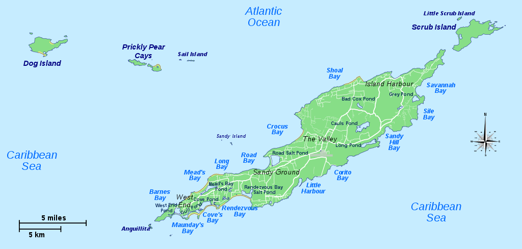
| Décripchon | Map of Anguilla and its main islands | ||
| Date | |||
| Source | |||
| Auteu | Hogweard | ||
| Pérmission (Réutilisacion éd chole fichier) |
|
||
| Autres versions | Macedonian |
Histoère dech fichié
Buke su eune date/heure pou vir ch'fichié conme il étoait ach momint-lo.
| Date/Tans | Tiote image | Diminsions | Uzeu | Fichié éd chés conmints | |
|---|---|---|---|---|---|
| courant | 3 ed Moai 2017 à 22:26 | | 8 669 × 4 128 (975 kio) | Hogweard | {{Information |Description=Map of Anguilla and its main islands |Source=*{{f|Anguilla blank.svg}} *{{f|Anguilla regions map.svg}} |Date=2017-05-03 |Author={{u|Hogweard}} |Permission={{PD-self}} |other_versions= }} Category:Maps of Anguilla |
Usage dech fichié
L'pache d'apreu est loyée à ch'fichié-lo :
Usage global du fichier
Chés eutes wikis suivants uzette chole fichier :
- Utilisacion édseur bn.wikipedia.org
- Utilisacion édseur de.wikipedia.org
- Utilisacion édseur en.wikipedia.org
- Utilisacion édseur es.wikipedia.org
- Utilisacion édseur fr.wikipedia.org
- Utilisacion édseur gl.wikipedia.org
- Utilisacion édseur id.wikipedia.org
- Utilisacion édseur ko.wikipedia.org
- Utilisacion édseur ml.wikipedia.org
- Utilisacion édseur uk.wikipedia.org