Fichier:Average precipitation in the lower 48 states of the USA.png

Taille éd chl' apérchu : 800 × 538 pixels. Eutes résolucions : 320 × 215 pixels | 640 × 430 pixels | 1 024 × 689 pixels | 1 280 × 861 pixels | 2 785 × 1 873 pixels.
Fichier d’origine (2 785 × 1 873 picséls, diminchon dech fichié: 2,19 Mio, MIME tipe: image/png)
Résumè
| Décripchon |
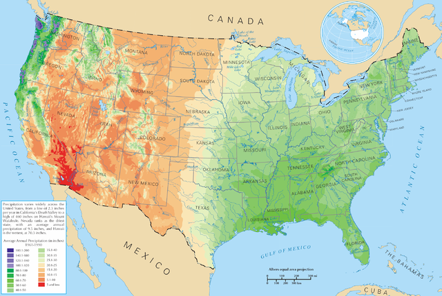
English: Average precipitation in the lower 48 states of the United States of America.
Español: Promedio de la precipitación de los 48 estados contiguos |
| Source | https://nationalmap.gov/small_scale/printable/climatemap.html |
| Auteu | département de l'Intérieur des États-Unis |
Licince
Cette carte a été obtenue d'une édition du
National Atlas of the United States . Comme presque toutes les œuvres du gouvernement fédéral des États-Unis d'Amérique, les travaux du National Atlas sont placés dans le domaine public.Version en ligne : NationalAtlas.gov | Édition imprimée de 1970 : Library of Congress, Perry-Castañeda Library
|
Histoère dech fichié
Buke su eune date/heure pou vir ch'fichié conme il étoait ach momint-lo.
| Date/Tans | Tiote image | Diminsions | Uzeu | Fichié éd chés conmints | |
|---|---|---|---|---|---|
| courant | 28 ed Marche 2006 à 21:08 | | 2 785 × 1 873 (2,19 Mio) | Tom | ==Description== Average precipitation in the lower 48 states of the United States of America. ==License== {{PD-USGov-Atlas}} |
Usage dech fichié
L'pache d'apreu est loyée à ch'fichié-lo :
Usage global du fichier
Chés eutes wikis suivants uzette chole fichier :
- Utilisacion édseur bg.wikipedia.org
- Utilisacion édseur cs.wikipedia.org
- Utilisacion édseur da.wikipedia.org
- Utilisacion édseur de.wikipedia.org
- Utilisacion édseur en.wikipedia.org
- Utilisacion édseur fr.wikipedia.org
- Utilisacion édseur hak.wikipedia.org
- Utilisacion édseur he.wikipedia.org
- Utilisacion édseur ht.wikipedia.org
- Utilisacion édseur hu.wikipedia.org
- Utilisacion édseur hy.wikipedia.org
- Utilisacion édseur id.wikipedia.org
- Utilisacion édseur ja.wikipedia.org
- Utilisacion édseur lg.wikipedia.org
- Utilisacion édseur mg.wikipedia.org
- Utilisacion édseur pl.wikipedia.org
- Utilisacion édseur pl.wiktionary.org
- Stany Zjednoczone
- Съединени щати
- Съединени американски щати
- Bandaríkin
- Bandaríki Norður-Ameríku
- Amerikan yhdysvallat
- Amerikka
- United States of America
- United States
- U.S.A.
- U.S.
- Stany Zjednoczone Ameryki
- Egyesült Államok
- Amerikai Egyesült Államok
- الولايات المتحدة
- Злучаныя Штаты Амерыкі
- fenua Marite
- ᐊᒥᐊᓕᑲ
- Amerikas förenta stater
- الولايات المتحدة الأمريكية
- Amerika Birləşmiş Ştatları
- Ameriketako Estatu Batuak
- Mokuʻāina-hui-ʻia
- АҚШ
Vir davantage édseur l’utilisacion globale éd chole fichié-lo.