Fichier:Iles Vierges britanniques carte.png
Poin éd pu grande résoluchon possibe.
Iles_Vierges_britanniques_carte.png (329 × 353 picséls, diminchon dech fichié: 30 kio, MIME tipe: image/png)
Résumè
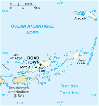
| Décripchon | Map in French of the British Virgin Islands |
| Date | translation : September 2006 |
| Source | CIA World Factbook |
| Auteu | of the translation : Eric Gaba (Sting) |
| Pérmission (Réutilisacion éd chole fichier) |
PD |
| Autres versions | original version in English : Image:BritishVirginIsland_map.png |
Français : * Sujet : Carte en français des Îles Vierges britanniques ;
- Source : CIA World Factbook ;
- Autre version disponible : anglophone : Image:BritishVirginIsland_map.png
- Auteur de la traduction : Eric Gaba (fr:Sting) ;
- Date : Septembre 2006.
Licince
Cette image est dans le domaine public parce que son contenu provient du World Factbook, édité par la Central Intelligence Agency des États-Unis d’Amérique.
|
 |
| This work was previously under Public Domain, or a Free License. It has been digitally enhanced and/or modified. This derivative work has been (or is hereby) released into the public domain by its author, Sting at the French Wikipedia project. This applies worldwide. In some countries this is not legally possible; if so:
|
Histoère dech fichié
Buke su eune date/heure pou vir ch'fichié conme il étoait ach momint-lo.
| Date/Tans | Tiote image | Diminsions | Uzeu | Fichié éd chés conmints | |
|---|---|---|---|---|---|
| courant | 25 ed Sétimbe 2006 à 12:32 | | 329 × 353 (30 kio) | Sting | {{Information |Description=Map in French of the British Virgin Islands |Source=[https://www.cia.gov/cia/publications/factbook/index.html CIA World Factbook] |Date=translation : September 2006 |Author=of the translation : Eric Gaba (Sting) | |
Usage dech fichié
L'pache d'apreu est loyée à ch'fichié-lo :
Usage global du fichier
Chés eutes wikis suivants uzette chole fichier :
- Utilisacion édseur azb.wikipedia.org
- Utilisacion édseur fr.wikipedia.org
- Utilisacion édseur gl.wikipedia.org
- Utilisacion édseur pl.wikipedia.org
- Utilisacion édseur pt.wikipedia.org