Fichier:Blackseecaucasuscoast.png
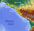
Blackseecaucasuscoast.png (276 × 248 picséls, diminchon dech fichié: 107 kio, MIME tipe: image/png)
Histoère dech fichié
Buke su eune date/heure pou vir ch'fichié conme il étoait ach momint-lo.
| Date/Tans | Tiote image | Diminsions | Uzeu | Fichié éd chés conmints | |
|---|---|---|---|---|---|
| courant | 5 d'Aout 2010 à 11:12 |  | 276 × 248 (107 kio) | DerFuchs | Correction of the map according to Nickpo's recommendations |
| 5 d'Aout 2010 à 10:48 |  | 276 × 248 (131 kio) | Nickpo | Reverted to version as of 02:32, 5 August 2010 | |
| 5 d'Aout 2010 à 10:34 |  | 276 × 248 (108 kio) | DerFuchs | Reverted, asked user. User_talk:Nickpo#Explain | |
| 5 d'Aout 2010 à 02:32 |  | 276 × 248 (131 kio) | Nickpo | Reverted to version as of 13:45, 15 November 2009 | |
| 4 d'Aout 2010 à 13:55 |  | 276 × 248 (108 kio) | DerFuchs | Correction, neutralization, addition. | |
| 15 ed Novimbe 2009 à 13:45 |  | 276 × 248 (131 kio) | Dinamik | orphography | |
| 3 ed Moai 2009 à 04:38 |  | 276 × 248 (118 kio) | Nickpo | {{Information |Description={{en|Black See Coast of Caucasus resort region map}}{{ru|Карта Черноморского побережья Кавказа}}{{legend|#FBF501|Города России}}{{legend|#FC50B6|Города Абхазии}}{{legend | |
| 2 ed Moai 2009 à 22:01 |  | 276 × 248 (116 kio) | Nickpo | {{Information |Description={{en|Black See Coast of Caucases map}}{{ru|Карта Черноморского побережья Кавказа}} |Source=own work based on Schwarzes Meer und Umgebung |Date=2009-05-0 |
Usage dech fichié
L'pache d'apreu est loyée à ch'fichié-lo :
Usage global du fichier
Chés eutes wikis suivants uzette chole fichier :
- Utilisacion édseur az.wikipedia.org
- Utilisacion édseur be.wikipedia.org
- Utilisacion édseur fr.wikipedia.org
- Utilisacion édseur os.wikipedia.org
- Utilisacion édseur ru.wikipedia.org
- Utilisacion édseur uk.wikipedia.org


