Fichier:DETAIL VIEW OF NORTHEAST END, DUTCH DOOR - Lanrick Manor, Barn, 137 South River Road, Yardley, Bucks County, PA HABS PA,9-YARD,3A-3.tif

Taille de cet aperçu JPG pour ce fichier TIF : 428 × 599 pixels. Eutes résolucions : 171 × 240 pixels | 343 × 480 pixels | 548 × 768 pixels | 731 × 1 024 pixels | 1 462 × 2 048 pixels | 3 570 × 5 000 pixels.
Fichier d’origine (3 570 × 5 000 picséls, diminchon dech fichié: 17,03 Mio, MIME tipe: image/tiff)
Résumè
| DETAIL VIEW OF NORTHEAST END, DUTCH DOOR - Lanrick Manor, Barn, 137 South River Road, Yardley, Bucks County, PA | ||||
|---|---|---|---|---|
| Titre |
DETAIL VIEW OF NORTHEAST END, DUTCH DOOR - Lanrick Manor, Barn, 137 South River Road, Yardley, Bucks County, PA |
|||
| Décripchon |
Klugh, T, transmitter; Boucher, Jack E, photographer |
|||
| Lieu représenté | Pennsylvania; Bucks County; Yardley | |||
| Date | Documentation compiled after 1933 | |||
| Dimensions | 5 x 7 in. | |||
| Lieu actuel |
Library of Congress Prints and Photographs Division Washington, D.C. 20540 USA http://hdl.loc.gov/loc.pnp/pp.print |
|||
| Numéro d’inventaire |
HABS PA,9-YARD,3A-3 |
|||
| Attribution de l’acquisition |
|
|||
| Notes |
|
|||
| Source | https://www.loc.gov/pictures/item/pa3148.photos.045311p | |||
| Pérmission (Réutilisacion éd chole fichier) |
|
|||

| Position de l'objet | | Voir cet endroit et d’autres images sur : OpenStreetMap |
|---|
Histoère dech fichié
Buke su eune date/heure pou vir ch'fichié conme il étoait ach momint-lo.
| Date/Tans | Tiote image | Diminsions | Uzeu | Fichié éd chés conmints | |
|---|---|---|---|---|---|
| courant | 31 ed Juillet 2014 à 23:57 | 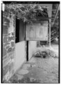 | 3 570 × 5 000 (17,03 Mio) | Fæ | GWToolset: Creating mediafile for Fæ. HABS 31 July 2014 (3000:3200) |
Usage dech fichié
L'pache d'apreu est loyée à ch'fichié-lo :