Fichier:Germania inferior roads towns.png

Taille éd chl' apérchu : 614 × 599 pixels. Eutes résolucions : 246 × 240 pixels | 492 × 480 pixels | 787 × 768 pixels | 1 162 × 1 134 pixels.
Fichier d’origine (1 162 × 1 134 picséls, diminchon dech fichié: 1,83 Mio, MIME tipe: image/png)
Résumè
| Décripchon |
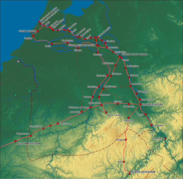
English: Roads and Towns in Germania Inferior
Nederlands: Wegen en Nerderzettingen in Germania Inferior |
| Date | |
| Source | eigen werk (own work), Modified from Germanie-inferieure.jpg by Moutschen based on a map from the DVD: Free Software Foundation Europe, Free Layers (licensed under GFDL). |
| Auteu | Hans Erren |
| Autres versions |
Germanie-inferieure.jpg by Moutschen  |
Licince
Moi, en tant que détenteur des droits d’auteur sur cette œuvre, je la publie sous les licences suivantes :

|
Os avez l' pérmission d' copier, distribuer pi modifier chol documint slon chés térmes del GNU Free Documentation License vérsion 1.2 obin toute vérsion ultérieure publièe pèr el Free Software Foundation, sans sékcions inaltérabes, sans teske d' prumière pache d' couvérture pi sans teske ed darène pache d' couvérture. Un egzimploère del licince est inclus dins l' sékcion intitulée GNU Free Documentation License. |
Ce fichier est sous licence Creative Commons Attribution – Partage dans les Mêmes Conditions 3.0 (non transposée), 2.5 Générique, 2.0 Générique et 1.0 Générique.
- Os ètes libe :
- éd partager – éd copier, distribuer pi transmète chole euve
- d’adapter – éd modifier chole euve
- Dsous chés condicions suivantes :
- patérnitè – Os d'vez donner chés informacions appropriées concernant l'auteu, fournir un loyen vers el licince, et indiquer si des modificacions ont tè foaites. Os povez foaire cha pèr tout moéyin raisonnabe, mais poin d'eune manière qui suggérerait qu’il vos soutienne o approuve l'utilisacion éq vos in foaites.
- partage à l’idintique – Si os modifiez, transformez, o os basez édseur chole euve, os d'vez distribuer vote contérbuchon dsous el meume licince o eune licince compatibe aveuc chole éd l'original.
Vous pouvez choisir l’une de ces licences.
Histoère dech fichié
Buke su eune date/heure pou vir ch'fichié conme il étoait ach momint-lo.
| Date/Tans | Tiote image | Diminsions | Uzeu | Fichié éd chés conmints | |
|---|---|---|---|---|---|
| courant | 16 ed Sétimbe 2009 à 23:06 | | 1 162 × 1 134 (1,83 Mio) | Hans Erren | road Forum Hadriani Noviomagus edited, location of Tablis and Caspingium moved, symbology and labels modified |
| 13 ed Sétimbe 2009 à 20:17 |  | 1 162 × 1 132 (1,84 Mio) | Hans Erren | Added province boundaries from Westermann Grosser Atlas zur Weltgeschichte 1972 | |
| 13 ed Sétimbe 2009 à 13:56 |  | 1 155 × 1 131 (1,83 Mio) | Hans Erren | {{Information |Description={{en|1=Roads and Towns in Germania Inferior}} {{nl|1=Wegen en Nerderzettingen in Germania Inferior}} |Source=Own work by uploader |Author=Hans Erren |Date= |Permission= |other_versions= }} == Summary == {{Inf |
Usage dech fichié
L'pache d'apreu est loyée à ch'fichié-lo :
Usage global du fichier
Chés eutes wikis suivants uzette chole fichier :
- Utilisacion édseur az.wikipedia.org
- Utilisacion édseur de.wikipedia.org
- Utilisacion édseur el.wikipedia.org
- Utilisacion édseur en.wikipedia.org
- Utilisacion édseur eo.wikipedia.org
- Utilisacion édseur es.wikipedia.org
- Utilisacion édseur fr.wikipedia.org
- Utilisacion édseur hr.wikipedia.org
- Utilisacion édseur it.wikipedia.org
- Utilisacion édseur kk.wikipedia.org
- Utilisacion édseur ko.wikipedia.org
- Utilisacion édseur la.wikipedia.org
- Utilisacion édseur mk.wikipedia.org
- Utilisacion édseur nl.wikipedia.org
- Utilisacion édseur pt.wikipedia.org
- Utilisacion édseur ro.wikipedia.org
- Utilisacion édseur ru.wikipedia.org
- Utilisacion édseur sq.wikipedia.org
- Utilisacion édseur uk.wikipedia.org