Fichier:Knowledge of French EU map.svg

Taille de cet aperçu PNG pour ce fichier SVG : 585 × 599 pixels. Eutes résolucions : 234 × 240 pixels | 468 × 480 pixels | 749 × 768 pixels | 999 × 1 024 pixels | 1 999 × 2 048 pixels | 1 212 × 1 242 pixels.
Fichier d’origine (Fichié SVG, résoluchon éd 1 212 × 1 242 picsels, diminchon: 549 kio)
Résumè
| Décripchon |
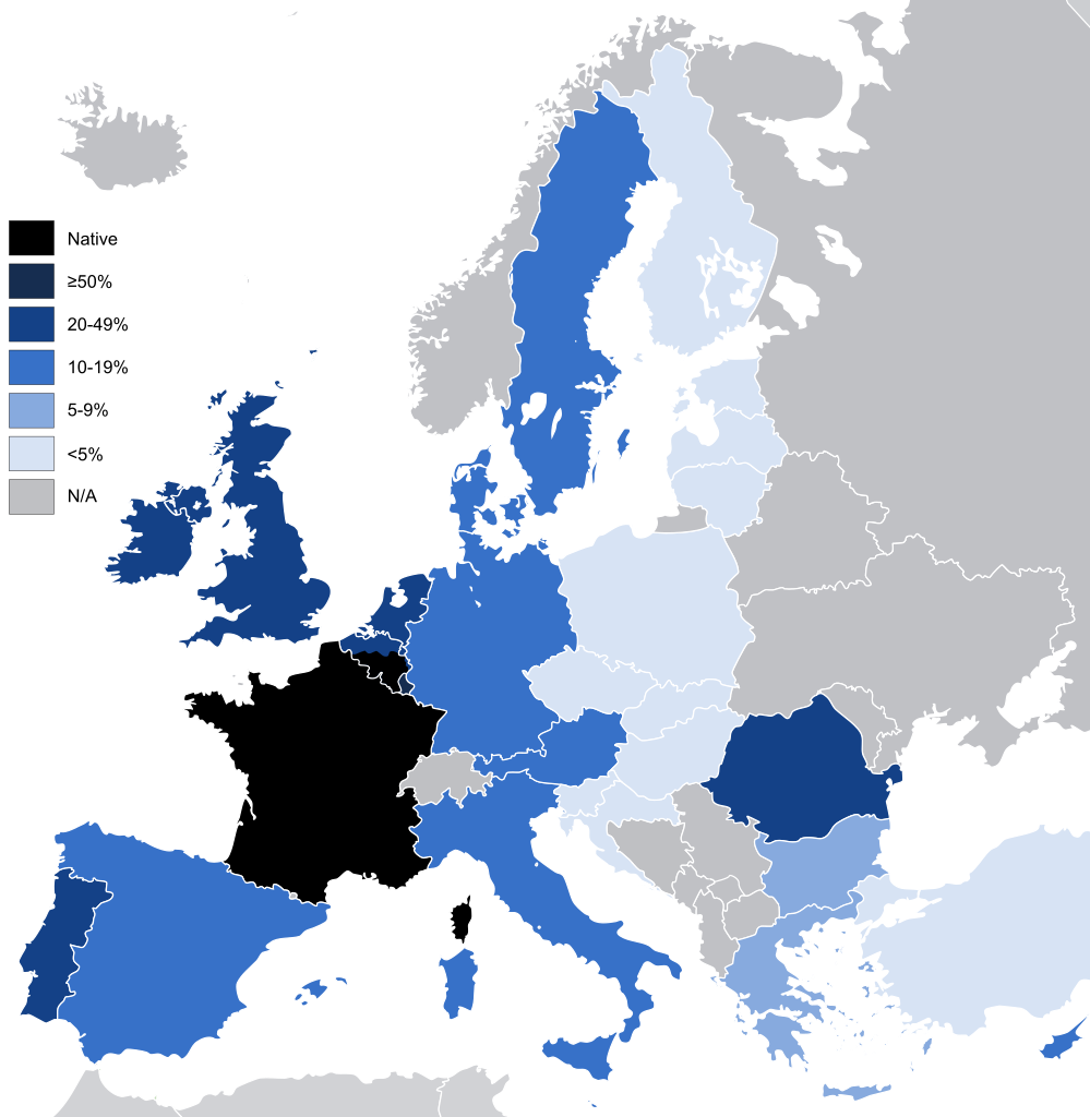
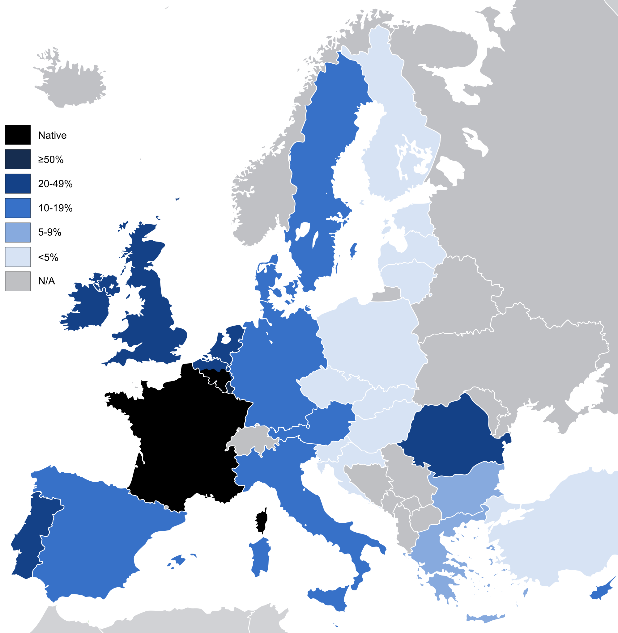
English: Knowledge French to a conversational level (other than as a mother tongue) in the European Union and the United Kingdom, according to: "Special Eurobarometer 243" of the European Commission with the title "Europeans and their Languages" [1]
|
| Date | |
| Source | Image:EU27-2008 European Union map.svg |
| Auteu | Addicted04 |
| Autres versions |
|

Licince
| Moi, propriétaire des droits d’auteur sur cette œuvre, la place dans le domaine public. Ceci s'applique dans le monde entier. Dans certains pays, ceci peut ne pas être possible ; dans ce cas : J’accorde à toute personne le droit d’utiliser cette œuvre dans n’importe quel but, sans aucune condition, sauf celles requises par la loi. |
Histoère dech fichié
Buke su eune date/heure pou vir ch'fichié conme il étoait ach momint-lo.
| Date/Tans | Tiote image | Diminsions | Uzeu | Fichié éd chés conmints | |
|---|---|---|---|---|---|
| courant | 14 ed Join 2021 à 06:42 | | 1 212 × 1 242 (549 kio) | Sbb1413 | Reverted to version as of 02:02, 3 January 2012 (UTC) Reverting to include the knowledge of French in the UK, despite no longer being part of the EU. Rewording the filedesc. |
| 3 ed Févrié 2020 à 10:50 |  | 1 212 × 1 242 (550 kio) | Darranc | Remove UK from EU | |
| 3 ed Janvié 2012 à 02:02 |  | 1 212 × 1 242 (549 kio) | Fenn-O-maniC | Added Wallonia | |
| 6 ed Marche 2011 à 18:51 |  | 1 212 × 1 242 (546 kio) | Alphathon | Fixed Swedish lakes | |
| 6 ed Marche 2011 à 18:43 |  | 1 212 × 1 242 (540 kio) | Alphathon | Added >5% category | |
| 28 d'Aout 2010 à 20:45 |  | 1 212 × 1 242 (517 kio) | Alphathon | Key borders and Irish lakes added | |
| 27 d'Aout 2010 à 14:15 |  | 1 212 × 1 242 (514 kio) | Alphathon | Cropped etc. for consistency with other, similar maps | |
| 17 d'Octobe 2009 à 18:27 |  | 680 × 520 (518 kio) | Addicted04 | map | |
| 27 ed Novimbe 2008 à 16:09 |  | 1 218 × 1 245 (2 kio) | SammyV~commonswiki | {{Information |Description={{en|1=Knowledge French in the European Union, according to: "Special Eurobarometer 243" of the European Commission with the title "Europeans and their Languages" }} |Source=Own work by uploader |Author=SammyV |D |
Usage dech fichié
L'pache d'apreu est loyée à ch'fichié-lo :
Usage global du fichier
Chés eutes wikis suivants uzette chole fichier :
- Utilisacion édseur ar.wikipedia.org
- Utilisacion édseur ast.wikipedia.org
- Utilisacion édseur ba.wikipedia.org
- Utilisacion édseur bg.wikipedia.org
- Utilisacion édseur bs.wikipedia.org
- Utilisacion édseur de.wikipedia.org
- Utilisacion édseur el.wikipedia.org
- Utilisacion édseur en.wikipedia.org
- Utilisacion édseur eo.wikipedia.org
- Utilisacion édseur es.wikipedia.org
- Utilisacion édseur fa.wikipedia.org
- Utilisacion édseur fi.wikipedia.org
- Utilisacion édseur fr.wikipedia.org
- Utilisacion édseur ga.wikipedia.org
- Utilisacion édseur gd.wiktionary.org
- Utilisacion édseur gl.wikipedia.org
- Utilisacion édseur he.wikipedia.org
- Utilisacion édseur hu.wikipedia.org
- Utilisacion édseur id.wikipedia.org
- Utilisacion édseur incubator.wikimedia.org
- Utilisacion édseur is.wikipedia.org
- Utilisacion édseur ja.wikipedia.org
- Utilisacion édseur kbp.wikipedia.org
- Utilisacion édseur kk.wikipedia.org
- Utilisacion édseur kk.wikibooks.org
- Utilisacion édseur lez.wikipedia.org
- Utilisacion édseur lfn.wikipedia.org
- Utilisacion édseur lmo.wikipedia.org
- Utilisacion édseur nl.wikipedia.org
- Utilisacion édseur olo.wikipedia.org
- Utilisacion édseur pfl.wikipedia.org
- Utilisacion édseur pl.wikipedia.org
- Utilisacion édseur pnb.wikipedia.org
- Utilisacion édseur ro.wikipedia.org
- Utilisacion édseur ru.wikipedia.org
Vir davantage édseur l’utilisacion globale éd chole fichié-lo.