Fichier:Manhattan Highlight New York City Map Julius Schorzman.png

Taille éd chl' apérchu : 616 × 600 pixels. Eutes résolucions : 247 × 240 pixels | 493 × 480 pixels | 789 × 768 pixels | 1 052 × 1 024 pixels | 2 104 × 2 048 pixels | 2 652 × 2 582 pixels.
Fichier d’origine (2 652 × 2 582 picséls, diminchon dech fichié: 4,68 Mio, MIME tipe: image/png)
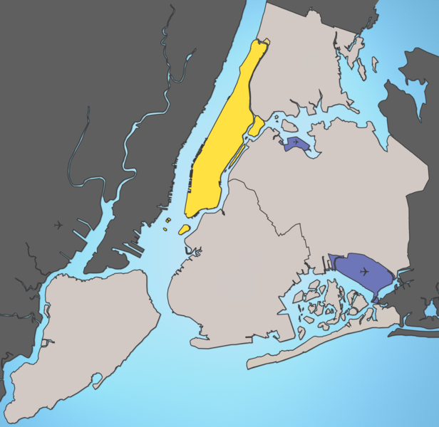
A map of New York City with Manhattan highlighted.
Notes:
- Marble Hill is shown as part Manhattan, part Bronx. See Wikipedia:Marble Hill, Manhattan, New York for more information.
- Governors Island, Ellis Island, Liberty Island, Randall's Island, and Roosevelt Island are highlighted since they are in New York County and are governmentally a part of Manhattan.
Source: I created this image using various maps and images. Attribution: Julius Schorzman
Ce fichier est disponible selon les termes de la licence Creative Commons Attribution – Partage dans les Mêmes Conditions 2.5 Générique
- Os ètes libe :
- éd partager – éd copier, distribuer pi transmète chole euve
- d’adapter – éd modifier chole euve
- Dsous chés condicions suivantes :
- patérnitè – Os d'vez donner chés informacions appropriées concernant l'auteu, fournir un loyen vers el licince, et indiquer si des modificacions ont tè foaites. Os povez foaire cha pèr tout moéyin raisonnabe, mais poin d'eune manière qui suggérerait qu’il vos soutienne o approuve l'utilisacion éq vos in foaites.
- partage à l’idintique – Si os modifiez, transformez, o os basez édseur chole euve, os d'vez distribuer vote contérbuchon dsous el meume licince o eune licince compatibe aveuc chole éd l'original.
Histoère dech fichié
Buke su eune date/heure pou vir ch'fichié conme il étoait ach momint-lo.
| Date/Tans | Tiote image | Diminsions | Uzeu | Fichié éd chés conmints | |
|---|---|---|---|---|---|
| courant | 19 d'Aout 2005 à 01:59 | | 2 652 × 2 582 (4,68 Mio) | Quasipalm | A map of New York City with Manhattan highlighted. Notes: # '''Marble Hill''' is shown as part Manhattan, part Bronx. See wiki:Marble Hill for more information. # '''Governors Island''', '''Ellis Island''', '''Liberty Island''', '''Randall's Island' |
| 19 d'Aout 2005 à 01:54 |  | 2 652 × 2 582 (4,68 Mio) | Quasipalm | A map of New York City with Manhattan highlighted. Notes: # '''Marble Hill''' is shown as part Manhattan, part Bronx. See wiki:Marble Hill for more information. # '''Governors Island''', '''Ellis Island''', '''Liberty Island''', '''Randall's Island' |
Usage dech fichié
L'pache d'apreu est loyée à ch'fichié-lo :
Usage global du fichier
Chés eutes wikis suivants uzette chole fichier :
- Utilisacion édseur bg.wikipedia.org
- Utilisacion édseur bn.wikipedia.org
- Utilisacion édseur bs.wikipedia.org
- Utilisacion édseur ca.wikipedia.org
- Utilisacion édseur de.wikipedia.org
- Utilisacion édseur en.wikipedia.org
- Utilisacion édseur es.wikipedia.org
- Utilisacion édseur fa.wikipedia.org
- Utilisacion édseur fo.wikipedia.org
- Utilisacion édseur frr.wikipedia.org
- Utilisacion édseur fr.wikipedia.org
- Utilisacion édseur ga.wikipedia.org
- Utilisacion édseur he.wikipedia.org
- Utilisacion édseur hr.wikipedia.org
- Utilisacion édseur hu.wikipedia.org
- Utilisacion édseur id.wikipedia.org
- Utilisacion édseur is.wikipedia.org
- Utilisacion édseur it.wikipedia.org
- Utilisacion édseur ja.wikipedia.org
- Utilisacion édseur ka.wikipedia.org
- Utilisacion édseur kn.wikipedia.org
- Utilisacion édseur lt.wikipedia.org
- Utilisacion édseur mk.wikipedia.org
- Utilisacion édseur mr.wikipedia.org
- Utilisacion édseur ms.wikipedia.org
- Utilisacion édseur pnb.wikipedia.org
- Utilisacion édseur pt.wikipedia.org
- Utilisacion édseur ro.wikipedia.org
- Utilisacion édseur ru.wikipedia.org
Vir davantage édseur l’utilisacion globale éd chole fichié-lo.