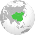
Fichier:Republic of China (orthographic projection).svg

Fichier d’origine (Fichié SVG, résoluchon éd 512 × 512 picsels, diminchon: 3,23 Mio)

Ch'fichié i vient éd Wikimedia Commons. I put ète uzé pèr d’eutes prodjés. Vir l'pache édseur Commons.

Any autoconfirmed user can overwrite this file from the same source. Please ensure that overwrites comply with the guideline.

Résumè

Décripchon
中文(简体):1953年至2005年期间中华民国法定领土
 
实际管辖区(中华民国自由地区)
 
国府迁台后曾主张但未实际统治的领土。其中的外蒙古及唐努乌梁海业已放弃主权声索。
中文(繁體):1953年至2005年期間中華民國訓政時期約定法定領土。
 
實際管轄區(中華民國自由地區)
 
國府遷臺後曾主張但未實際統治的領土。其中的外蒙古及唐努烏梁海業已放棄主權聲索。
English: Territories claimed by Republic of China from 1953 to 2005.
 
Actual administrative area (Free area of the Republic of China)
 
Territories claimed
Français : Territoires revendiqués par la République de Chine de 1953 à 2005.
 
Territoires revendiqués
Español: Territorio reclamado por República de China de 1953 a 2005.
 
Actual área de la república (Área libre de la República de China)
 
Territorios anteriormente pertenencientes a la república y actualmente reclamados
閩南語 / Bân-lâm-gú:Tiong-huâ-bîn-kok(tshim li̍k-sik) ki̍p kî suan-tshing ióng-iú tsú-khuân ê tē-khu(tshián li̍k-sik).
Українська: Республіка Китай
 
Територія під контролем Республіки Китай (Вільна зона Республіки Китай)
 
Територія, на яку претендує Республіка Китай
Date
Source Traval parsonnel
Auteu PhiLiP
This is a Grey & green orthographic projection map.
العربية: الرجاء، قراءة الميثاق.
বাংলা: দয়া করে, রীতিনীতিটি পড়ুন
Deutsch: Bitte lies die Konventionen.
English: Please, read the conventions.
Español: Por favor, lea las convenciones.
Filipino: Paki-basa ang mga kumbensyon.
Français : S'il vous plaît, lisez les conventions.
हिन्दी: कृपया सभागमों को पढ़ लें.
Bahasa Indonesia: Silakan, baca konvensi.
Italiano: Si prega di leggere le convenzioni.
日本語: 規約をご確認ください。
ქართული: გთხოვთ, გაეცნოთ კონვენციებს.
Português: Por favor, leia as convenções.
Русский: Пожалуйста, прочитайте соглашения.
Українська: Будь ласка, прочитайте конвенції.
Tiếng Việt: Hãy đọc công văn trước khi đăng.
中文(繁體):請檢視常規
中文(简体):请查看常规
World maps

Africa

हिन्दी: अफ्रीका
ქართული: აფრიკა.

Eastern Africa

Southern Africa

Central Africa

Northern Africa

Western Africa

Americas

ქართული: ამერიკა.
हिन्दी: अमेरिका

North America

Central America

Caribbean

South America

Asia

ქართული: აზია.
Português: Ásia.
Українська: Азія.

East

Português: Ásia Oriental.
Українська: Східна Азія.

Central

हिन्दी: मध्य एशिया
Português: Ásia Central.
Українська: Центральна Азія.

Southeast

Bahasa Indonesia: Asia tenggara
Português: Sudeste Asiático.

South

(भारतीय उपमहाद्वीप)
Português: Sul da Ásia.
Українська: Південна Азія.

Western

Português: Sudoeste da Ásia.
Українська: Передня Азія.

Europe

हिन्दी: यूरोप
ქართული: ევროპა.
Português: Europa.
Română: Europa.
Русский: Европа.
Українська: Європа.

Countries

Oceania

हिन्दी: ओशिआनिया
ქართული: ოკეანეთი.
Português: Oceania.
Українська: Океанія.

Intercontinental

Português: Intercontinental.
Українська: Міжконтинентальні.

Historical

English: Unions, Organizations, Kingdoms, Empires
Español: Uniones, Organizaciones, Reinos, Imperios
Filipino: Mga Unyon, Organisasyon, Kaharian, Imperyo
Français : Unions, Organisations, Royaumes, Empires
हिन्दी: संघ, संगठन, राज्य, साम्राज्य व ऐतिहासिक देश
ქართული: გაერთიანებები, ორგანიზაციები, სამეფოები, იმპერიები
Português: Estados extintos.
Tagalog: Mga Unyon, Organisasyon, Kaharian, Imperyo
Українська: Союзи, Організації, Королівства, Імперії
中文(繁體):聯盟、組織、王國和帝國
中文(简体):联盟、组织、王国和帝国

Subnationals

हिन्दी: उपराष्ट्रीय इकाईयाँ

Licince

Moi, en tant que détenteur des droits d’auteur sur cette œuvre, je la publie sous les licences suivantes :
GNU head Os avez l' pérmission d' copier, distribuer pi modifier chol documint slon chés térmes del GNU Free Documentation License vérsion 1.2 obin toute vérsion ultérieure publièe pèr el Free Software Foundation, sans sékcions inaltérabes, sans teske d' prumière pache d' couvérture pi sans teske ed darène pache d' couvérture. Un egzimploère del licince est inclus dins l' sékcion intitulée GNU Free Documentation License.
w:fr:Creative Commons
patérnitè partage à l’idintique
Ech fichié-lo il est disponibe slon chés térmes del licince Creative Commons Attribucion - Partage dins chés meumes Conditions 3.0 (poin transposée).
Os ètes libe :
  • éd partager – éd copier, distribuer pi transmète chole euve
  • d’adapter – éd modifier chole euve
Dsous chés condicions suivantes :
  • patérnitè – Os d'vez donner chés informacions appropriées concernant l'auteu, fournir un loyen vers el licince, et indiquer si des modificacions ont tè foaites. Os povez foaire cha pèr tout moéyin raisonnabe, mais poin d'eune manière qui suggérerait qu’il vos soutienne o approuve l'utilisacion éq vos in foaites.
  • partage à l’idintique – Si os modifiez, transformez, o os basez édseur chole euve, os d'vez distribuer vote contérbuchon dsous el meume licince o eune licince compatibe aveuc chole éd l'original.
Vous pouvez choisir l’une de ces licences.
Annotations
InfoField
This image is annotated: View the annotations at Commons

Légendes

Ajoutez en une ligne la description de ce que représente ce fichier
Republic of China (orthographic projection)

Éléments décrits dans ce fichier

dépeint français

créé par français

Valeur sans élément de Wikidata

29 d'Octobe 2009

type MIME français

image/svg+xml

Histoère dech fichié

Buke su eune date/heure pou vir ch'fichié conme il étoait ach momint-lo.

Date/TansTiote imageDiminsionsUzeuFichié éd chés conmints
courant19 ed Join 2024 à 12:45Image pou l'vérchon éd 19 ed Join 2024 à 12:45512 × 512 (3,23 Mio)Lilauid修訂多處邊界
26 d'Avri 2024 à 00:55Image pou l'vérchon éd 26 d'Avri 2024 à 00:55512 × 512 (3,22 Mio)Lilauid參照1979年5月《第一屆國民大會第六次會議實錄》所附的《中華民國全圖》細化邊界
29 ed Déchimbe 2019 à 15:54Image pou l'vérchon éd 29 ed Déchimbe 2019 à 15:54541 × 541 (319 kio)Goran tek-enAdded border for South Sudan as requested by Maphobbyist
3 ed Févrié 2012 à 19:35Image pou l'vérchon éd 3 ed Févrié 2012 à 19:35541 × 541 (598 kio)白布飘扬Colour changed
1 ed Févrié 2012 à 03:09Image pou l'vérchon éd 1 ed Févrié 2012 à 03:09541 × 541 (598 kio)白布飘扬More territories claimed by ROC added: * Tannu Uriankhai (Tyva Republic, Russia), * Sixty-Four Villages East of the Amur River (now controled by Russia), * northern part of Myanmar, * eastern part of Bhutan, * most area of Gorno-Badakhstan, Tajikistan, *
29 d'Octobe 2009 à 10:12Image pou l'vérchon éd 29 d'Octobe 2009 à 10:12541 × 541 (598 kio)PhiLiP{{Information |Description={{zh-hans|1=中华民国(深绿色)及其宣称拥有主权的地区(浅绿色)。}} |Source=Own work |Author=User:PhiLiP |Date=2009-10-29 |Permission= |other_versions= }}

Autchune pache n'est loïée aveuc ch'fichié-lo

Usage global du fichier

Chés eutes wikis suivants uzette chole fichier :

Vir davantage édseur l’utilisacion globale éd chole fichié-lo.

Metadata