Fichier:Syrdaryamap.png
Taille éd chl' apérchu : 719 × 600 pixels. Eutes résolucions : 288 × 240 pixels | 576 × 480 pixels | 820 × 684 pixels.
Fichier d’origine (820 × 684 picséls, diminchon dech fichié: 936 kio, MIME tipe: image/png)
Résumè

|
Cette image (de type carte) devrait être recréée dans un format vectoriel, en tant que fichier SVG. Cela offrirait plusieurs avantages : voir Commons:Media for cleanup pour plus d'informations. Si une version SVG de cette image est déjà disponible, merci de bien vouloir l'envoyer. Après cela, remplacez ce modèle par {{vector version available|nouveau nom d'image.svg}}.
|
| Décripchon |
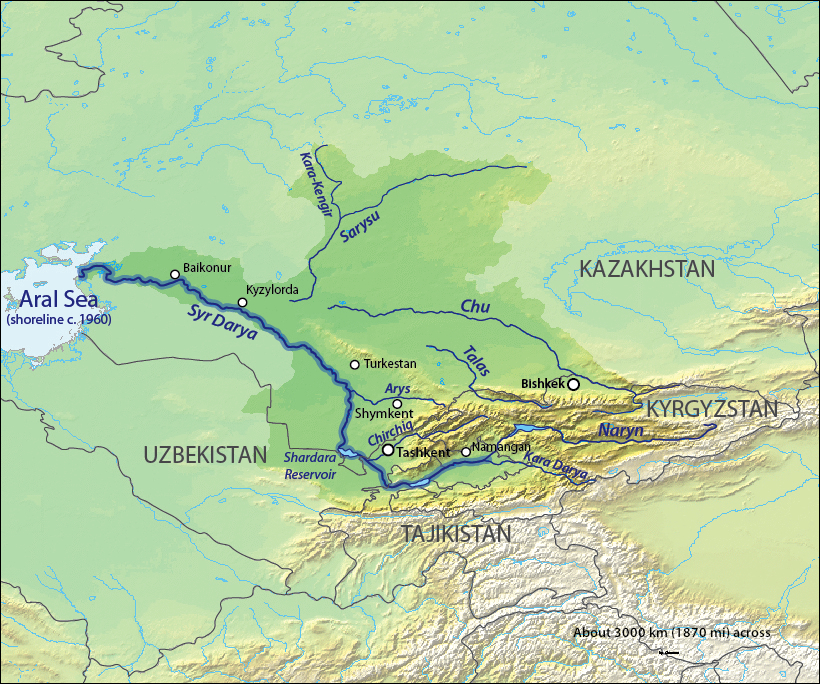
English: Map of the Syr Darya Basin watershed, of the Syr Darya and Chu Rivers — in Central Asia.
Қазақша: Сырдария
Татарча / tatarça: Сырдәрья |
| Date | to 06 |
| Source | Background and river course data from http://www2.demis.nl/mapserver/mapper.asp |
| Auteu | Background layer attributed to DEMIS Mapserver, map created by Shannon1 |
| Pérmission (Réutilisacion éd chole fichier) |
Map created from DEMIS Mapserver, which are public domain. |
| Autres versions |
Œuvres dérivées de ce fichier : |
Licince
Moi, en tant que détenteur des droits d’auteur sur cette œuvre, je la publie sous les licences suivantes :

|
Os avez l' pérmission d' copier, distribuer pi modifier chol documint slon chés térmes del GNU Free Documentation License vérsion 1.2 obin toute vérsion ultérieure publièe pèr el Free Software Foundation, sans sékcions inaltérabes, sans teske d' prumière pache d' couvérture pi sans teske ed darène pache d' couvérture. Un egzimploère del licince est inclus dins l' sékcion intitulée GNU Free Documentation License. |
This file is licensed under the Creative Commons Attribution-Share Alike 4.0 International, 3.0 Unported, 2.5 Generic, 2.0 Generic and 1.0 Generic license.
- Os ètes libe :
- éd partager – éd copier, distribuer pi transmète chole euve
- d’adapter – éd modifier chole euve
- Dsous chés condicions suivantes :
- patérnitè – Os d'vez donner chés informacions appropriées concernant l'auteu, fournir un loyen vers el licince, et indiquer si des modificacions ont tè foaites. Os povez foaire cha pèr tout moéyin raisonnabe, mais poin d'eune manière qui suggérerait qu’il vos soutienne o approuve l'utilisacion éq vos in foaites.
- partage à l’idintique – Si os modifiez, transformez, o os basez édseur chole euve, os d'vez distribuer vote contérbuchon dsous el meume licince o eune licince compatibe aveuc chole éd l'original.
Vous pouvez choisir l’une de ces licences.
Histoère dech fichié
Buke su eune date/heure pou vir ch'fichié conme il étoait ach momint-lo.
| Date/Tans | Tiote image | Diminsions | Uzeu | Fichié éd chés conmints | |
|---|---|---|---|---|---|
| courant | 18 d'Octobe 2013 à 03:11 | | 820 × 684 (936 kio) | Shannon1 | redrew and fixed watershed boundary |
| 8 ed Janvié 2011 à 09:21 |  | 1 101 × 866 (1,65 Mio) | Sibom | chu | |
| 8 ed Janvié 2011 à 09:20 |  | 1 101 × 866 (1,65 Mio) | Sibom | чу | |
| 7 ed Févrié 2010 à 03:04 |  | 1 101 × 866 (1,51 Mio) | Shannon1 | {{Information |Description={{en|1=Map of the watershed of the Syr Darya in Central Asia, that drains to the Aral Sea.}} |Source=Background and river course data from http://www2.demis.nl/mapserver/mapper.asp |Author=Background layer attributed to DEMIS M |
Usage dech fichié
L'pache d'apreu est loyée à ch'fichié-lo :
Usage global du fichier
Chés eutes wikis suivants uzette chole fichier :
- Utilisacion édseur af.wikipedia.org
- Utilisacion édseur ar.wikipedia.org
- Utilisacion édseur ast.wikipedia.org
- Utilisacion édseur bg.wikipedia.org
- Utilisacion édseur bh.wikipedia.org
- Utilisacion édseur bn.wikipedia.org
- Utilisacion édseur cs.wikipedia.org
- Utilisacion édseur cv.wikipedia.org
- Utilisacion édseur da.wikipedia.org
- Utilisacion édseur de.wikipedia.org
- Utilisacion édseur en.wikipedia.org
- Utilisacion édseur es.wikipedia.org
- Utilisacion édseur et.wikipedia.org
- Utilisacion édseur fi.wikipedia.org
- Utilisacion édseur fr.wikipedia.org
- Utilisacion édseur he.wikipedia.org
- Utilisacion édseur hi.wikipedia.org
- Utilisacion édseur hr.wikipedia.org
- Utilisacion édseur hu.wikipedia.org
- Utilisacion édseur hy.wikipedia.org
- Utilisacion édseur id.wikipedia.org
Vir davantage édseur l’utilisacion globale éd chole fichié-lo.