Fichier:Union of Soviet Socialist Republics (orthographic projection).svg

Taille de cet aperçu PNG pour ce fichier SVG : 541 × 541 pixels. Eutes résolucions : 240 × 240 pixels | 480 × 480 pixels | 768 × 768 pixels | 1 024 × 1 024 pixels | 2 048 × 2 048 pixels.
Fichier d’origine (Fichié SVG, résoluchon éd 541 × 541 picsels, diminchon: 453 kio)
Résumè
| Décripchon |
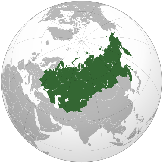
English: The Union of Soviet Socialist Republics (Soviet Union) |
||||
| Date | |||||
| Source |
Own work, Cette image vectorielle non W3C-spécifiée a été créée avec Inkscape . Aquarius.geomar.de
|
||||
| Auteu | Ssolbergj | ||||
| Autres versions |
.svg)
|
.svg)
.svg)
.svg)
.svg)
.svg)
.svg)
.svg)
.svg)
.svg)
.svg)
.svg)
.svg)
.svg)
.svg)
.svg)
.svg)
.svg)
.svg)
.svg)
.svg)
.svg)
.svg)
.svg)
.svg)
.svg)
.svg)
.svg)
.svg)
.svg)
.svg)
.svg)
.svg)
.svg)
.svg)
.svg)
.svg)
.svg)
.svg)
.svg)
.svg)
.svg)
.svg)
.svg)
.svg)
.svg)
.svg)
.svg)
.svg)
.svg)
.svg)
.svg)
.svg)
.svg)
.svg)
.svg)
.svg)
.svg)
.svg)
.svg)
.svg)
.svg)
.svg)
.svg)
.svg)
.svg)
.svg)
.svg)
.svg)
.svg)
.svg)
.svg)
.svg)
.svg)

.svg)

.svg)

.svg)
.svg)
.svg)
.svg)
.svg)
.svg)
.svg)


.svg)
.svg)
.svg)
.svg)
.svg)
.svg)
.svg)

.svg)
.svg)
.svg)
.svg)
.svg)
.svg)
.svg)
.svg)
.svg)
.svg)

.svg)
.svg)
.svg)
.svg)
.svg)
.svg)
.svg)
_without_national_boundaries.svg)
.svg)
.svg)
.svg)
.svg)
.svg)
.svg)

.svg)
.svg)
.png)
.svg)
.svg)
.svg)
.svg)

.svg)
.svg)
.svg)
.svg)
.svg)
.svg)
.svg)
.svg)
.svg)
.svg)
.svg)

.svg)
.svg)
.svg)
.svg)
.svg)
.svg)
.svg)
.svg)
.svg)

.svg)
.svg)

.svg)
.svg)
.svg)
.svg)
.svg)
.svg)
.svg)
.svg)
.svg)
.svg)
.svg)
.svg)
.svg)
.svg)
.svg)
.svg)
.svg)
.svg)
.svg)
.svg)
.svg)
.svg)
.svg)
.svg)
.svg)
.svg)
.svg)
_-_Crimea_disputed.svg)
.svg)
.svg)
.svg)
.svg)
.svg)
.svg)
.svg)
.svg)
.svg)
.svg)
.svg)
_political.svg)
.svg)
.svg)
.svg)
.svg)
_-_Crimea_disputed_-_no_borders.svg)
.svg)
.svg)
.svg)
.svg)
.svg)
.svg)
.svg)
.svg)
.svg)
.svg)
.svg)

.svg)
.svg)
.svg)

.png)
.svg)
.svg)
.svg)
.svg)
.svg)
.svg)
.svg)
.svg)
.svg)
.svg)
.svg)
.svg)
.svg)
.svg)
.svg)
.svg)
.svg)
.svg)
.svg)
.svg)
.svg)
.svg)
.svg)
.svg)
.svg)
.svg)
.svg)
.svg)
.svg)
.svg)
.svg)
.svg)
.svg)
.svg)
.png)
.svg)
.svg)
.svg)
_(orthographic_projection).png)
.svg)
.svg)
.svg)
Licince
Moi, en tant que détenteur des droits d’auteur sur cette œuvre, je la publie sous les licences suivantes :
Ech fichié-lo il est disponibe slon chés térmes del licince Creative Commons Attribucion - Partage dins chés meumes Conditions 3.0 (poin transposée).
- Os ètes libe :
- éd partager – éd copier, distribuer pi transmète chole euve
- d’adapter – éd modifier chole euve
- Dsous chés condicions suivantes :
- patérnitè – Os d'vez donner chés informacions appropriées concernant l'auteu, fournir un loyen vers el licince, et indiquer si des modificacions ont tè foaites. Os povez foaire cha pèr tout moéyin raisonnabe, mais poin d'eune manière qui suggérerait qu’il vos soutienne o approuve l'utilisacion éq vos in foaites.
- partage à l’idintique – Si os modifiez, transformez, o os basez édseur chole euve, os d'vez distribuer vote contérbuchon dsous el meume licince o eune licince compatibe aveuc chole éd l'original.

|
Os avez l' pérmission d' copier, distribuer pi modifier chol documint slon chés térmes del GNU Free Documentation License vérsion 1.2 obin toute vérsion ultérieure publièe pèr el Free Software Foundation, sans sékcions inaltérabes, sans teske d' prumière pache d' couvérture pi sans teske ed darène pache d' couvérture. Un egzimploère del licince est inclus dins l' sékcion intitulée GNU Free Documentation License. |
Vous pouvez choisir l’une de ces licences.
Histoère dech fichié
Buke su eune date/heure pou vir ch'fichié conme il étoait ach momint-lo.
| Date/Tans | Tiote image | Diminsions | Uzeu | Fichié éd chés conmints | |
|---|---|---|---|---|---|
| courant | 7 ed Déchimbe 2021 à 13:52 | | 541 × 541 (453 kio) | Kappasi | Removed nonexistent lake in the Amur. |
| 30 ed Marche 2009 à 01:56 |  | 541 × 541 (521 kio) | Ssolbergj | {{Information |Description={{en|1=The Union of Soviet Socialist Republics (Soviet Union)}} |Source=Own work, {{Inkscape}}<br />[http://www.aquarius.geomar.de/omc/make_map.html Aquarius.geomar.de]<br />{{GFDL-GMT}} |Author=Ssolbergj |Dat |
Usage dech fichié
L'pache d'apreu est loyée à ch'fichié-lo :
Usage global du fichier
Chés eutes wikis suivants uzette chole fichier :
- Utilisacion édseur af.wikipedia.org
- Utilisacion édseur af.wiktionary.org
- Utilisacion édseur als.wikipedia.org
- Utilisacion édseur am.wikipedia.org
- Utilisacion édseur ang.wikipedia.org
- Utilisacion édseur ar.wikipedia.org
- Utilisacion édseur ar.wiktionary.org
- Utilisacion édseur ast.wiktionary.org
- Utilisacion édseur as.wikipedia.org
- Utilisacion édseur avk.wikipedia.org
- Utilisacion édseur av.wikipedia.org
- Utilisacion édseur azb.wikipedia.org
- Utilisacion édseur az.wiktionary.org
- Utilisacion édseur ban.wikipedia.org
- Utilisacion édseur ba.wikipedia.org
- Utilisacion édseur be-tarask.wikipedia.org
- Utilisacion édseur be.wikipedia.org
- Utilisacion édseur bg.wikipedia.org
- Utilisacion édseur bh.wikipedia.org
- Utilisacion édseur bn.wikipedia.org
- Utilisacion édseur bo.wikipedia.org
- Utilisacion édseur bs.wikipedia.org
- Utilisacion édseur bxr.wikipedia.org
- Utilisacion édseur cdo.wikipedia.org
- Utilisacion édseur ceb.wikipedia.org
- Utilisacion édseur ce.wikipedia.org
- Utilisacion édseur ckb.wikipedia.org
- Utilisacion édseur cs.wikipedia.org
- Utilisacion édseur cs.wikiquote.org
- Utilisacion édseur cu.wikipedia.org
- Utilisacion édseur de.wikipedia.org
- Utilisacion édseur de.wikibooks.org
- Utilisacion édseur de.wiktionary.org
- Utilisacion édseur dsb.wikipedia.org
- Utilisacion édseur el.wikipedia.org
Vir davantage édseur l’utilisacion globale éd chole fichié-lo.
.svg)
.svg)